Delta takes a westerly jog
Published 11:38 am Wednesday, October 7, 2020
|
Getting your Trinity Audio player ready...
|
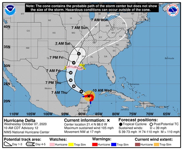
The National Hurricane Center has released the latest information regarding Hurricane Delta. In that release, the Center has shown the storm taking a slight jog to the west.
That means impacts to our area could be lessened as the storm moves onshore. The expected landfall is currently late Friday or early Saturday, according to tracking information.
Conditions as of 10 a.m. Wednesday morning are:
MAXIMUM SUSTAINED WINDS...105 MPH...165 KM/H PRESENT MOVEMENT...NW OR 305 DEGREES AT 17 MPH...28 KM/H MINIMUM CENTRAL PRESSURE...975 MB...28.80 INCHES Warnings already issued along the Gulf Coast include:
A Storm Surge Watch has been issued for the northern Gulf coast from High Island, Texas, to the Alabama/Florida border including Calcasieu Lake, Vermilion Bay, Lake Pontchartrain, Lake Maurepas, Lake Borgne and Mobile Bay. A Hurricane Watch has been issued for the northern Gulf coast from High Island, Texas, eastward to Grand Isle, Louisiana. A Tropical Storm Watch has been issued along the Texas coast from west of High Island to San Luis Pass. A Tropical Storm Watch has also been issued along the northern Gulf coast from east of Grand Isle, Louisiana, to Bay St. Louis, Mississippi, including the city of New Orleans, Lake Pontchartrain and Lake Maurepas.